
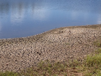
Drought Planning & Preparedness
CISA partners with several organizations in the Carolinas, and across the country, to enhance the region’s capacity to plan for and respond to drought. CISA’s portfolio of drought projects include research to better understand the wide range of drought impacts, engagement with different audiences and decision makers to address drought questions and information needs, and development of innovative tools and resources to assist with drought monitoring and planning. CISA’s drought projects are funded by the NOAA RISA program and the National Integrated Drought Information System (NIDIS).

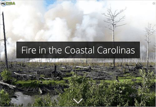
In 2017-2019, CISA and the National Integrated Drought Information System (NIDIS) provided support to the State Climate Office of North Carolina (SCONC) to expand the Coastal Carolinas DEWS Coastal Zone Fire Risk Assessment project conducted in 2014-2015. The purpose of this project is to provide organic soil moisture data and information to aid coastal zone fire risk monitoring and management. Traditional measures of drought and fire risk do not fully capture the organic soil conditions which can vary widely in terms of their terrain, root zone depth, and water table height. Local changes make monitoring conditions such as fire and smoldering risk a challenge, and few real-time monitoring stations have historically been present in remote areas. In 2018-2019 the SCONC deployed four organic soil moisture monitoring stations at locations in eastern North Carolina. Current and archived data from these stations are accessible on the SCONC’s Fire Weather Intelligence Portal where they provide real-time information for drought monitoring and fire risk decision making for the NC Forest Service, NC State Parks, and The Nature Conservancy. Learn more in this project overview.
Project Partner
- State Climate Office of North Carolina
Focus Area
Coastal Climate; Water Resources
The Carolinas Precipitation Patterns & Probabilities Atlas (Atlas) provides Carolinas-focused information about extremes (drought, heavy rainfall) and normal precipitation patterns. The Atlas includes over 1,000 downloadable maps and figures characterizing various measures of precipitation and drought. It offers information not readily available from other sources, such as frequency and duration of both dry and wet events, and photographs, videos, graphics, and narratives of the impacts of notable drought and heavy precipitation events in the Carolinas
CISA Collaborators
Greg Carbone
Karen Beidel
Junyu Lu
Chip Konrad
Project Partner
- Southeast Regional Climate Center
Focus Area
Water Resources
This project engages with citizen scientists and the Community Collaborative Rain, Hail, and Snow (CoCoRaHS) Network to promote drought impacts reporting. Observers provide weekly “condition monitoring” reports to document effects of weather and climate on their communities. This project addresses a need identified by stakeholders for improved understanding of drought impacts and for tools to facilitate the use of impacts information into decision making.
Read more about the Condition Monitoring project.
Access the Condition Monitoring Web Map.
CISA Collaborators
Ellie Davis
Amanda Farris
Kerry Guiseppe
Kirsten Lackstrom
Project Partners
- CoCoRaHS
- National Drought Mitigation Center
- State Climate Office of North Carolina
Focus Area
Water Resources
The NIDIS Coastal Carolinas DEWS program is a collaborative federal, state, and local interagency effort to improve early warning capacity and resilience to drought in the Carolinas with an emphasis on coastal areas. CISA has contributed to the Coastal Carolinas DEWS through several efforts.
- The Citizen Science-Condition Monitoring project expanded drought impacts monitoring and reporting in the Carolinas. Tools and information developed through the Carolinas pilot are now available as a national-level resource through the Community Collaborative Rain, Hail & Snow (CoCoRaHS) network.
- The Carolinas Precipitation Patterns & Probabilities Atlas provides Carolinas-focused information about extremes (drought, heavy rainfall) and normal precipitation patterns.
- The Coastal Salinity Index was developed as a tool to characterize coastal drought and monitoring changing salinities in coastal surface-water bodies.
- CISA has supported the establishment of an organic soil moisture monitoring network in eastern North Carolina.
- CISA has co- organized several stakeholder events since the DEWS was initiated in 2012, including the 2012 scoping workshop and 2016 planning meeting.
Access the NIDIS Coastal Carolinas DEWS page
CISA Collaborators
Greg Carbone
Kirstin Dow
Amanda Farris
Kirsten Lackstrom
Project Partners
- State Climate Office of North Carolina
- USGS South Atlantic Water Science Center
Focus Area
Coastal Climate; Water Resources
The Coastal Salinity Index (CSI) was developed as a way to characterize coastal drought by monitoring the freshwater-saltwater interface. The tool is intended to improve understanding of the effects of changing salinities on fresh and saltwater ecosystems, fish habitat, and freshwater availability for municipal and industrial use. In collaboration with partners from the USGS South Atlantic Water Science Center, CISA is engaging with decision makers to pilot the CSI’s use and applications.
Read more about the Coastal Salinity Index and related research
CISA Collaborators
Kirsten Lackstrom
Lauren Rouen
Dan Tufford
Project Partners
- East Carolina University
- USGS South Atlantic Water Science Center
Focus Area
Coastal Climate; Water Resources
This research project shows connections between growing season droughts and reductions in crop yields. The research aims to “detrend” the time series to account for technological changes that have improved crop yields through time. Maps displaying NC and SC county-level yield anomalies for corn (1925-2016), soybean (1972-2016), and hay (1950-2008) are available in the Carolinas Precipitation Patterns & Probabilities Atlas.
CISA Collaborators
Greg Carbone
Junyu Lu
Focus Area
Water Resources
CISA and the South Carolina State Climatology Office (SC SCO) initiated this project in 2017 with the overarching goal of enhancing the State’s Drought Response Program and improving drought preparedness and response. Major components of this project have included two statewide drought tabletop exercises and developing informational resources for the new scdrought.com website.
Read more about the CISA and SC SCO drought response project
CISA Collaborators
Ekaterina Altman
Amanda Farris
Kirsten Lackstrom
Project Partners
- South Carolina State Climatology Office
Focus Area
Water Resources